Discover all Societies Maps on eMap.pk: Your Ultimate Digital Mapping Solution for Pakistan
Introduction
eMap.pk is revolutionizing the way we navigate and understand the geographical landscape of Pakistan. With its comprehensive digital mapping services, eMap.pk offers an array of features that cater to the needs of individuals, businesses, and government entities. This article explores the myriad functionalities and benefits of eMap.pk, highlighting how it stands out as a premier mapping solution in Pakistan.
Comprehensive Mapping Features
Detailed Geographic Information
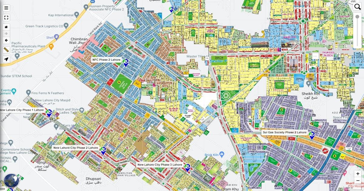
eMap.pk provides users with detailed and accurate maps of Pakistan, including cities, towns, and rural areas. The platform is continuously updated to ensure the most current geographic data is available. Users can access information on streets, landmarks, and even remote locations, making it an indispensable tool for navigation and planning.
Interactive User Interface
The platform boasts an interactive user interface that is both user-friendly and intuitive. Users can easily zoom in and out, search for specific locations, and toggle between different map views such as satellite, terrain, and street views. This versatility makes eMap.pk suitable for a wide range of applications from daily commuting to detailed geographic analysis.
Real-Time Traffic Updates
One of the standout features of eMap.pk is its real-time traffic updates. By providing live traffic data, users can plan their routes more efficiently, avoiding congested areas and reducing travel time. This feature is particularly useful for urban commuters and logistics companies looking to optimize their operations.
Business Solutions
Location-Based Services
For businesses, eMap.pk offers robust location-based services that can enhance customer engagement and operational efficiency. Businesses can integrate eMap.pk’s mapping solutions into their websites and applications, providing customers with accurate location information and navigation assistance.
Geographic Information System (GIS) Integration
eMap.pk supports Geographic Information System (GIS) integration, enabling businesses and government organizations to perform advanced spatial analysis. This feature is crucial for urban planning, resource management, and disaster response planning.
Benefits for Various Sectors
Real Estate
In the real estate sector, eMap.pk provides detailed property maps that help buyers and sellers visualize property locations and surroundings. This can greatly enhance the decision-making process and streamline property transactions.
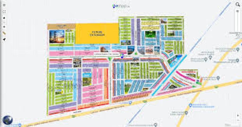
Featured Societies
Bahria Town Explore the extensive layout and amenities of Bahria Town with eMap.pk. Find detailed maps of residential areas, commercial zones, and recreational facilities.
DHA (Defence Housing Authority) Navigate through the well-planned sectors and modern infrastructure of DHA with ease using eMap.pk’s comprehensive maps and real-time updates.
Blue World City Discover Blue World City’s unique offerings and layout. eMap.pk provides detailed maps and information on this emerging housing society.
Gulberg Greens Get detailed insights into the lush green spaces and residential blocks of Gulberg Greens, enhancing your navigation and planning.
Eighteen Islamabad Explore the luxurious community of Eighteen Islamabad with detailed maps and real-time updates, ensuring you can navigate this premium location efficiently.
Capital Smart City Leverage eMap.pk to explore Capital Smart City, Pakistan's first smart city, with detailed layouts and information on its innovative infrastructure.
Gwadar Port City Navigate through the rapidly developing Gwadar Port City, utilizing eMap.pk’s comprehensive mapping to stay updated on new developments.
Lake City Lahore Discover Lake City Lahore’s serene environment and detailed community layouts with eMap.pk’s precise mapping services.
Al-Kabir Town Explore Al-Kabir Town’s residential and commercial areas, with accurate maps and navigation support from eMap.pk.
New Metro City Stay updated with the latest developments in New Metro City using eMap.pk’s detailed maps and real-time traffic updates.
Tourism
Tourism businesses can leverage eMap.pk to offer tourists detailed maps of attractions, hotels, and restaurants. Interactive maps can enrich the tourist experience, making it easier for visitors to explore and navigate new destinations.
Emergency Services
Emergency services can benefit from eMap.pk’s precise mapping and real-time data features. Accurate location information can significantly improve response times and coordination during emergencies, potentially saving lives.
Future Prospects
Continuous Updates and Enhancements
eMap.pk is committed to continuous improvement, regularly updating its maps and adding new features based on user feedback and technological advancements. The platform aims to incorporate more real-time data sources and enhance its predictive analytics capabilities.
Expansion and Collaboration
Future plans for eMap.pk include expanding its services to cover more regions and collaborating with international mapping organizations. This will ensure that eMap.pk remains at the forefront of digital mapping solutions, providing unparalleled service to its users.
Conclusion
eMap.pk is setting new standards in digital mapping for Pakistan. With its comprehensive features, user-friendly interface, and real-time data capabilities, it is an essential tool for individuals, businesses, and government entities alike. Whether you are navigating urban streets, planning business operations, or responding to emergencies, eMap.pk offers the precision and reliability you need.
For more information and to start exploring eMap.pk, visit their official website today.
By embracing the cutting-edge technology offered by eMap.pk, users can enhance their navigation experiences, improve business operations, and contribute to efficient urban planning and emergency response.